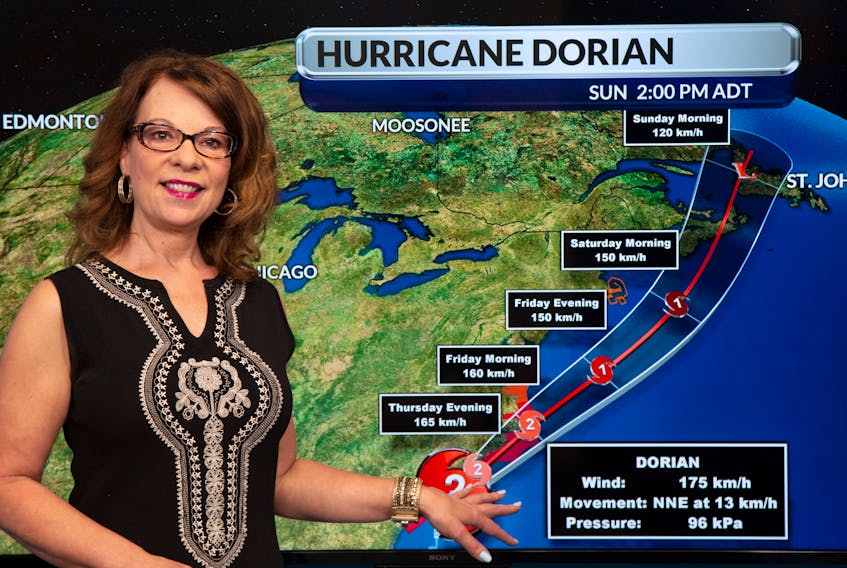
Saturday is a beautiful day in Newfoundland and Labrador as Dorian makes its way toward Nova Scotia as a Category 1 hurricane. It will be another eight hours before the system is expected to make landfall in this province.
The current track brings it along the west coast early Sunday morning with winds of 100 to 120 km/h, eventually heading to the Labrador Sea as a tropical depression.
There’s currently a hurricane warning for the west coast and southwest corner of the island with sustained winds expected around 119 km/h.
Along the southwest coast and Northern Peninsula there’s a tropical storm warning with sustained winds expected around 63 to 118 km/h.
“It does barrel through pretty quickly,” said SaltWire Network meteorologist Cindy Day about the storm’s path across Atlantic Canada.
“It’s powerful, but it’s short-lived.”
The storm is not expected to be as significant on the Avalon and Burin Peninsulas, where wind gusts are expected around 70 to 90 km/h.
Along the south coast of the island, waves are expected to reach 11 to 12 metres by Sunday morning.
Unlike the other Atlantic provinces, this is not expected to be a rain event for in Newfoundland and Labrador. Rainfall is expected to be about 20 to 30 mm.
Storm preparation
Newfoundland Power says its watching the forecast closely as Dorian moves toward the island, but recommends people charge their phones and ensure emergency kits are ready in the event of a power outage.
Marine Atlantic advises of disruptions in its crossings schedule as sea conditions worsen.
As a result of the expected storm impact along Newfoundland’s west coast, Gros Morne National Park, and the Port au Choix, L’Anse aux Meadows and Red Bay national historic sites will be closed.
The Department of Municipal Affairs and Environment is encouraging residents to be prepared for adverse weather conditions this weekend.
Municipalities and local service districts have been asked to review their emergency management plans and ensure that infrastructure such as roads, ditches and drains are clear of debris, and appropriate provisions are made for the delivery of services during anticipated weather events.
Residents should know the risks associated with adverse weather conditions in their communities, develop their own emergency plan and assemble an emergency kit. Having supplies on hand, including food, water, batteries and a portable radio, is important.
Also, items such as patio furniture and barbecues on decks should be secured.