While the rest of the island’s residents have already had their first snowfall workout in recent weeks, the St. John’s region and most of the Avalon Peninsula have gotten off easy.
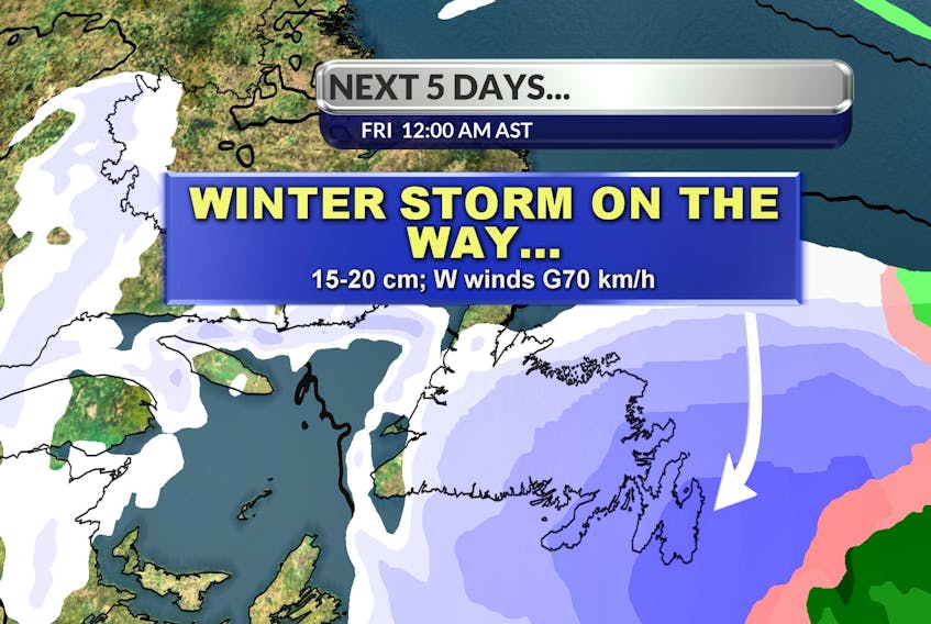
That will likely change Friday morning with an approaching system ready to drop upwards of 20 centimetres of snow on the Northeast Avalon overnight on Thursday.
“It's really going to be a snow event,” says SaltWire Network Meteorologist Cindy Day.

“Sometimes with these systems, there'll be some mixing and it'll keep the numbers down, but this system is staying offshore by quite a bit, so we're going to be on the colder side of the system.”
Day says people on the Burin Peninsula could get 15 cm, while those in the Clarenville and Bonavista areas should have about 10 to 15 of white stuff to clean up on Friday morning. Gander and vicinity are due for roughly 5 cm with that number decreasing to the west.
Snow removal will be made more challenging by the fact that after the snow moves out around 10 or 11 a.m. Friday morning, winds are forecast to pick up significantly from the west.
“I would imagine whiteout conditions through much of the day Friday even though the snow has been wrapping up,” explains Day, who says there’s a good chance Environment Canada will issue blizzard warnings on Friday morning thanks to a snowfall over 15 cms, blowing snow and reduced visibility.
The good news is that the snow will be of the light and fluffy variety, not the wet snow.
On the subject of temperatures, Day says the spate of mild weather on the eastern end of the province is at an end. Daytime temperatures won’t break 0 C for the next number of days and the feel-like-temperature will be in the -10 to -15 range thanks to the windchill.
Labrador and the west coast of the island, meanwhile, will remain quiet throughout the snow event and into the weekend thanks to a blocking high-pressure system over the Big Land.
Check out Day's full forecast.