BADGER, N.L.
Colleen Paul’s family has lived along the Exploits River for generations. She says for as long as she can she remember, flooding has always been a risk for those who made their home along this waterway.
Now that the provincial and federal government have invested nearly $2 million for new flood risk mapping projects, Paul is hopeful this money will better protect the residents in Badger and other communities around the Exploits.
“Since earliest times the Indigenous people in our community have lived along the river in Badger and we’ve continued to occupy it,” she said. “I hope this funding will help us forecast and anticipate when the river will be problematic. Flood forecasting, emergency response and public communication, these are all great tools for being better prepared for flood disasters.”
The funding, announced Nov. 14, is for flood risk projects along the Exploits and Humber rivers, as well one project focusing on municipal water supply dams.

A crucial need
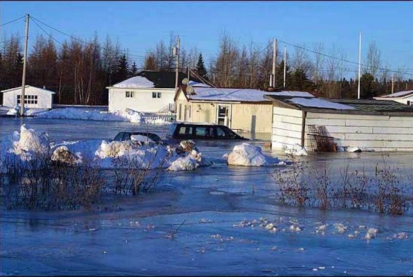
Paul is the Vice President of Na’taqamtug (meaning “At the Riverbank”) Cultural Group of Badger and a client service officer with the Qalipu First Nation. She says the flooding she experienced in her childhood was much different than the increasingly dangerous flooding she has witnessed in recent years. The flood of Badger in 2003 that resulted in extensive damage, an evacuation, and the loss of her mother’s home, particularly stands out.
“Flooding of the river was almost an annual event. My ancestors knew the river well and they knew when it was about to awaken, that’s what happened when you settled on a flood plain,” Paul said. “I remember my father would walk into the house in the middle of night and calmly tell my mother to gather the children and some clothes and we would go to our cousin’s house . . . . on a much higher level.
“As a child there was no panic in that, but it seems from year to year flooding is becoming more of a disaster than a natural occurrence. As the development of the flood plain has increased, the damage has also increased.”
In an emailed response, the Dept. of Municipal Affairs and Environment says this new Exploits River Communities Climate Change Flood Risk Mapping Study will incorporate several initiatives.
Lidar and aerial photography will be collected, river cross-sections will be surveyed, and updates will be made to the Badger Ice Progression Flood Warning Model by incorporating the latest data on flood levels and radar images of ice along the Exploits.
“Things are changing all over the world. What was once 100-year flood patterns are becoming 10-year floods because the frequency of seeing these sizeable floods is increasing.”
-Memorial University professor, Sue Ziegler
This model has not been updated since 1995.
“The maps will be crucial for municipal and emergency planning,” the email stated. “[The studies] will include an extensive infrastructure assessment of all bridges and culverts in the flood plains to see which are most vulnerable to flooding.”
Sue Ziegler, Memorial University professor with the Dept. of Earth Sciences, is currently studying aquatic and terrestrial ecosystems around the northwest Atlantic, and how climate change is affecting rivers of the province is a significant portion of her research.
She says there are changes in flood patterns being noted in rivers across the globe, and this funding is crucial to better protecting residents and the environment.
“Things are changing all over the world. What was once 100-year flood patterns are becoming 10-year floods because the frequency of seeing these sizeable floods is increasing,” Ziegler said. “In places like Newfoundland you’ve got ice too, which gives a whole different dynamic.
“These climate change studies are absolutely essential for the viability of these communities.”

Realizing the dangers
The flood risks in Badger largely occur in the spring when the ice thaws. Areas like Buchans and Millertown have also been affected by increasing flood damage from Red Indian Lake, which the Exploits River flows out of.
Because of where they are situated near the Exploits, some communities like Botwood or Norris Arm are not as prone to the threat of flooding. But Norris Arm Mayor Ross Rowsell says the nearby community of Sandy Point has a higher likelihood of experiencing floods.
“A lot of the houses in that community are very close to the riverside,” Rowsell said.
“Flood forecasting will improve with this announcement and these are all positive contributions, but that river will still do what that river wants to do. It always has.”
-Vice President of Na’taqamtug, Colleen Paul
Newfoundland and Labrador Hydro, which operates hydro dams and generating stations along the Exploits River, said in an emailed response that the company will be providing site access and safety support during the mapping project and is pleased to assist further if needed.
The Dept. of Municipal Affairs and Environment expects the project to be completed by March 2020.
As this funding moves into implementation, Paul feels it’s important to recognize this type of project can better protect the area and its residents, but it cannot prevent the flooding itself.
“We have to step back and realize the impacts climate change and economic development are having on our environment. The events are going to become more and more disastrous as these decades go on,” she said.
“Flood forecasting will improve with this announcement and these are all positive contributions, but that river will still do what that river wants to do. It always has.”
Tell us what you think!
Write us a letter to the editor and email it to [email protected]. Be sure to include a name, address and daytime telephone number where the author can be contacted. Letters should be no more than 300 words.