PROVINCIAL, N.L.
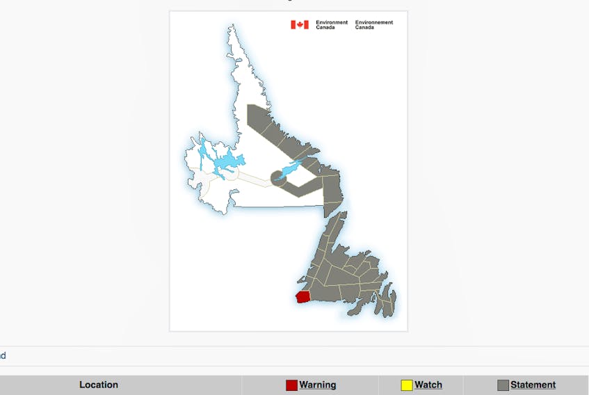
There’s some inclement weather on the way this week, with Environment Canada posting special weather statements — and a Wreckhouse wind warning — for all of the island, while portions of Labrador have significant snowfall in the forecast.
Following is a list of areas for which special weather statements/warning have been issued:
ISLAND
Environment Canada has issued a Wreckhouse wind warning for:
Channel-Port aux Basques and vicinity
Strong winds are expected or occurring.
Strong southeasterly winds gusting to 100 km/h are forecast to develop in the Wreckhouse area Wednesday afternoon, Jan. 9 and strengthen Wednesday night.
Be prepared to adjust your driving with changing road conditions due to high winds.
Wreckhouse wind warnings are issued when there is a significant risk of damaging winds.
Special weather statements are in effect for all the remaining regions of the island portion of Newfoundland and Labrador:
• Port Saunders and the Straits
• Parson's Pond - Hawke's Bay
• Gros Morne
• Northern Peninsula East
• Corner Brook and vicinity
• Bay St. George
• Burgeo - Ramea
• Deer Lake - Humber Valley
• Green Bay - White Bay
• Connaigre
• Buchans and the interior
• Grand Falls-Windsor and vicinity
• Gander and vicinity
• Bay of Exploits
• Bonavista North
• Bonavista Peninsula
• Terra Nova
• Burin Peninsula
• Avalon Peninsula Southwest
• Avalon Peninsula North
• Avalon Peninsula Southeast
• St. John's and vicinity
Environment Canada forecasts a mixed bag of precipitation Wednesday night, Jan. 9 into Thursday night, Jan. 10.
A low pressure system is forecast to approach from the west on Wednesday. Snow is expected to transition through freezing precipitation to rain for most of the island Wednesday night and Thursday morning.
While it is too soon to determine precipitation amounts, it appears snowfall will be greatest over western and northern Newfoundland, while rainfall will be greatest in the southeast. A significant period of freezing precipitation is possible over the east and northeast.
In addition, strong southeasterly winds are forecast to begin in southwestern Newfoundland during the day on Wednesday. The strong winds are expected along the west coast, especially in areas prone to enhanced easterlies. A Wreckhouse wind warning (as noted above) has been issued for Wednesday afternoon and night.
LABRADOR
Environment Canada has also issued a special weather statement for areas of Labrador, with significant snowfall possible late in the week for:
• Nain and vicinity
• Hopedale and vicinity
• Postville – Makkovik
• Rigolet and vicinity
• Cartwright to Black Tickle
• Norman Bay to Lodge Bay
• Red Bay to L'Anse-au-Clair
• Eagle River
• Upper Lake Melville
Environment Canada indicates a low pressure system is forecast to approach from the southwest on Wednesday, Jan. 9.
Snow is expected to begin over western Labrador Wednesday night and spread eastwards and northwards to all areas on Thursday, Jan. 10. The potential exists for the snow to continue over northern Labrador into Saturday, Jan. 12.While it is too soon to determine snowfall amounts, substantial totals are likely to occur over some areas.
For updated weather statement information from Environment Canada visit: https://weather.gc.ca/warnings/index_e.html?prov=nl
To report severe weather, send an email to [email protected] or tweet reports using #NLwx.