The first day of winter is just hours away – meteorological winter, that is. Astronomical winter begins on Dec. 21 this year, but meteorological winter always runs from Dec. 1 to the last day of February.
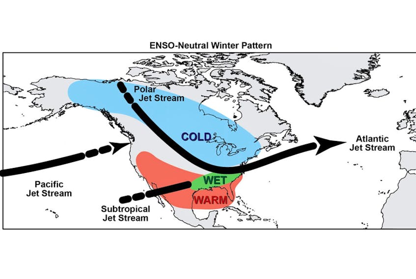
Some people like to take the weather as it comes. I’m glad that’s not the case with everyone, or I’d be out of work. Others seem to need more than seven days’ notice; these are the people who look forward to the seasonal ENSO forecasts. ENSO is El Niño/La Niña-Southern Oscillation. It’s a quasi-periodic climate pattern that occurs across the eastern Pacific Ocean roughly every five years. The Southern Oscillation refers to variations in the temperature of the surface of the tropical eastern Pacific Ocean and the air surface pressure in the tropical western Pacific. The warming of the ocean water is known as El Niño and the cooling is referred to as La Niña. The warm oceanic phase, El Niño, accompanies high air surface pressure in the western Pacific, while the cold phase, La Niña, accompanies low air surface pressure in the western Pacific.
Earlier this month, the International Research Institute for Climate and Society declared that we are in a near-neutral phase of the ENSO. So, what does it mean for our winter?
Well, a neutral cycle usually results in a dip in the polar jet stream. That allows currents of cold air to sweep down across the country from the prairies to the east coast. Typically, Atlantic Canadians would end up with slightly colder than normal temperatures and higher than average precipitation. Yes, that means a snowy winter for most.
Now without wanting to make excuses, I have to point out that while it is true these patterns are global steering patterns that do affect our weather, it’s very important to keep in mind it’s a general statement covering a very large piece of property. Local conditions can, and often do vary from ENSO predictions.
In the meantime, I am excited about the prospect of using my new snowshoes this winter.
- Visit your weather site.
- Have a weather question, photo or drawing to share with Cindy Day? Email [email protected]
Cindy Day is the chief meteorologist for SaltWire Network.